Explore the Stunning Trek of the Mengketu Ancient Road, Don't Miss This Hidden Gem in Xinjiang
On the first night at a small hotel in Kuitun, my mind was buzzing with thoughts about the word "eternal", since Mengketu means “never melting snow peak” in Mongolian. The next morning, I hopped on the leader’s old Mitsubishi, heading south along the Duku Highway, and by the time we got to the drop-off point at Ku Yang Lin, it was already 11:30 AM. The first step onto the riverbed sent chills up my spine, but that wasn’t the worst part—oh no, the sun was blazing down on me, and within ten minutes, I was regretting not putting sunscreen behind my ears.
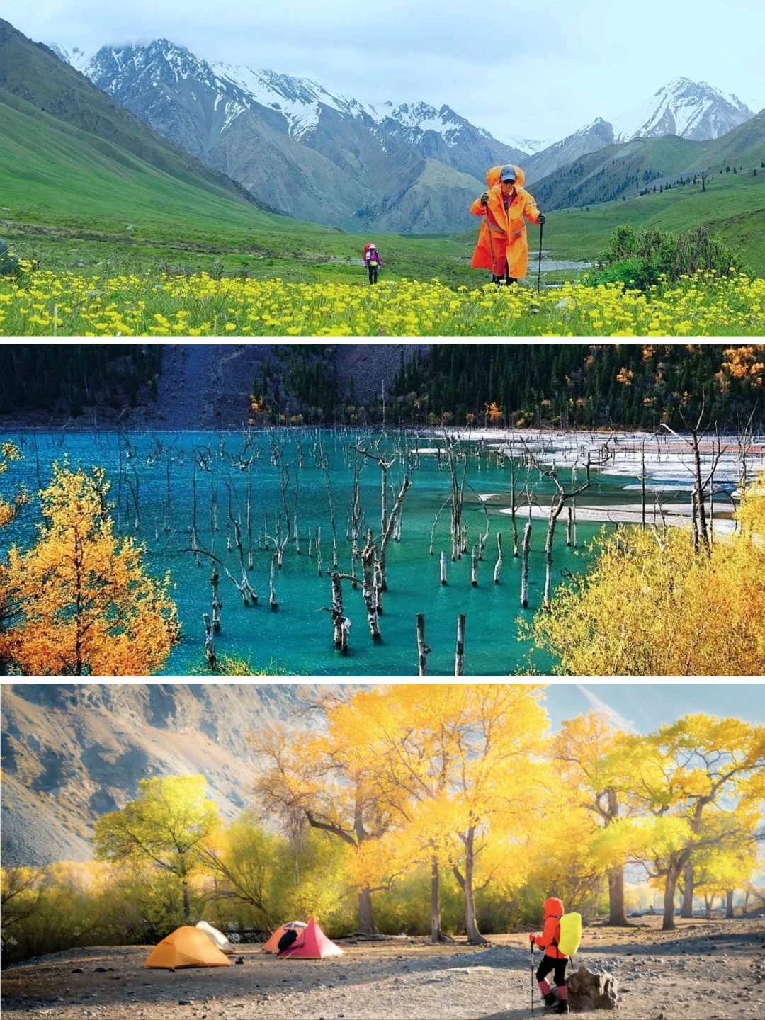
Once I truly hit the ancient path, the first thing that greeted me was a long stretch of old riverbed covered in round stones, making my feet tingle. Right from the start, we were doing 12 km, 5 hours, and there was no escaping blisters on my feet. But as I walked, the sky turned an unbelievable blue, the poplars cast huge shades like umbrellas, and a gentle breeze brought the faint scent of the trees. We finally reached camp at 8 PM, and even though it was still bright outside, I peeked out of the tent and saw—the snow-capped mountains looked like a freshly baked cream cake, the sunset painting it in a soft orange-pink, instantly healing my soul.
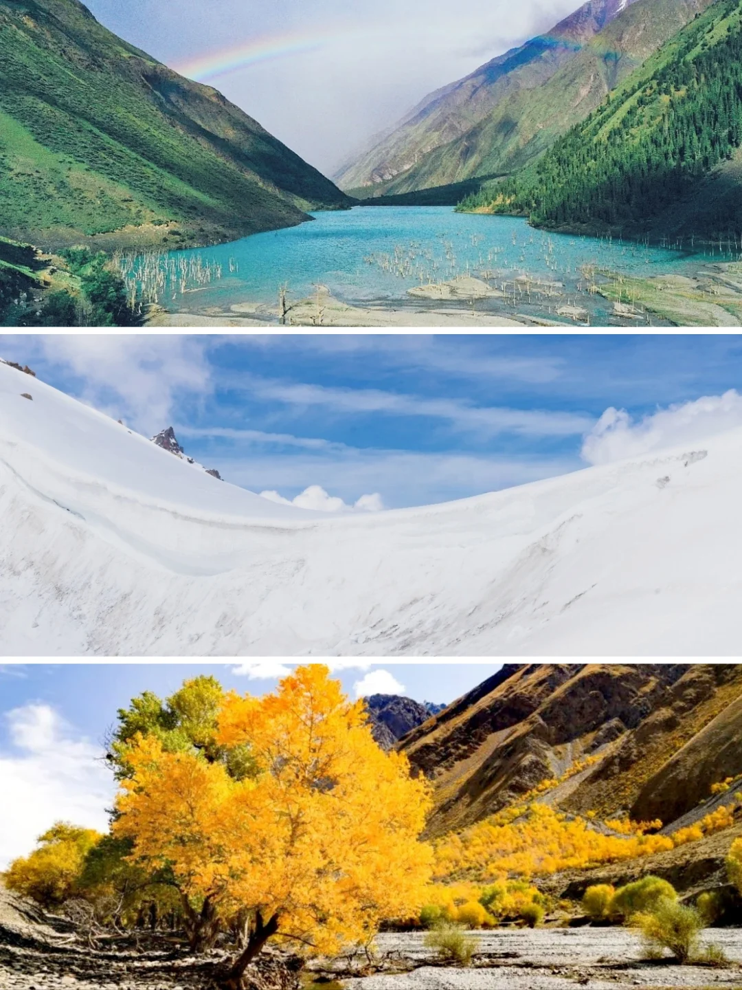
The next day at Tianhu (Ulan Sadek Naoer) was like a postcard come to life. The lake was like a mirror, pulling the snow peaks down to itself. I walked around the lake, which took me a whole hour. It’s only 5 km, but it was all rocky ups and downs; I ended up taking almost 8 hours. We could camp by the grass at the lake, but remember to book your spots in advance—two guys from our team arrived late and almost got sent back by the manager.
On the third day, we hiked from the forest camp to the Dongde Sala camp, which felt like a 15 km uphill treadmill. As I went through the pine forest, the wind hit me so hard I ended up putting on every piece of clothing I had: fleece, down jacket, and shell jacket all came out. The worst part was crossing a little stream; the water was bone-chilling, and my shoes got soaked. That night, I was drying my socks until midnight, and we huddled around the alcohol stove sharing a piece of naan. Everyone felt that the day was worth it because wild lilies were blooming along the way, looking as if someone had spilled daylight all over them.
The fourth day was the toughest—Mengketing Daban. One-third of the 14 km was rocky slopes above the snow line. I leaned on my trekking poles and counted 800 steps nonstop to reach the top. Standing at the pass with the wind slicing my face, seeing the 360° snow-capped mountains surrounding me was a feeling I would never forget. In the afternoon, we descended to the hot spring camp, and I was so exhausted I stuck my feet directly into the spring water, about 42°C, soaking away all the cold of the day.
On the fifth morning, I woke up still half-asleep, only to be called up by my buddies for a photo op. The morning mist enveloped the entire river valley, like someone pouring milk from the top down. The last 14 km of the trek to Tangbula National Forest Park went by, and as we emerged from the mountains, my phone immediately got a full signal. That’s when I saw my parents had already sent 99+ messages in our group chat. We hired a car back to Yining to catch the midnight sleeper train to Urumqi, and the train rocked me to sleep like a baby, waking up the next morning at 7:55 AM, just in time for breakfast at the South Station.
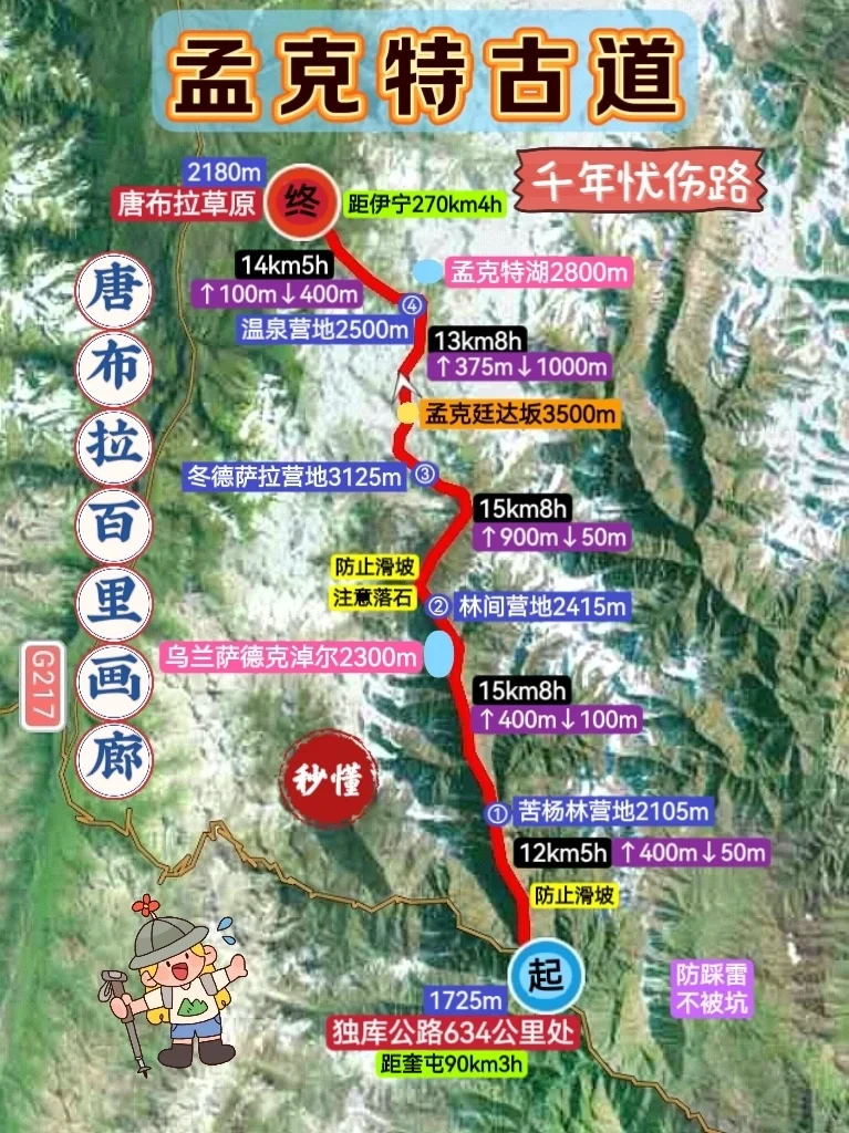
Itinerary Overview
| DAY | Segment | Distance/Time | My Impressions |
|---|
| 1 | Ku Yang Lin Camp | 12 km / 5 h | Sunburn, Poplar shade, Riverbed pebbles |
| 2 | Tianhu Camp | 5 km / 8 h | Mirror lake, Rocky slopes, Wild strawberries |
| 3 | Dongde Sala | 15 km / 8 h | Pine forest, Cold creek, Wet shoes, Wild lilies |
| 4 | Daban Hot Springs | 13 km / 8 h | Steep snowy slopes, 360° snow mountains, Warm-foot springs |
| 5 | Tangbula Exit | 14 km / 5 h | Morning mist over the river, Full signal at the exit |
Don't Forget These Gear Essentials
- Clothes: During the day, it was 37°C under the sun, and at night it dropped to 2°C with snow flurries; my quick-dry base layer + fleece + 800 g down + outer shell were totally enough.
- Shoes: High-top hiking shoes + gaiters; when I crossed the river without gaiters, I ended up with freezing water in my shoes; I brought three pairs of wool socks and two pairs of quick-dry, but I used them all up by the third day.
- Sleep System: 1000 g down sleeping bag + egg carton pad kept me cozy at night. For the tent, I picked a lightweight double-layer; the wind at night was strong enough to turn the outer layer into a kite.
- Small Items: Sunscreen SPF 50++ + lip balm + sunglasses + buff; my face and neck areas I missed with sunscreen turned into raw beef color.
- Food: Breakfast oatmeal + milk powder, lunch Snickers + beef jerky + raisins to keep me going, and in the evening, we would gather to cook pasta and throw in an egg. High-calorie cheese candy was a lifesaver; I devoured 500 g in three days.
Some Pitfalls No One Told Me
- Confirm water sources with teammates in advance: There were 3 hours with no clean water before and after Tianhu; I almost choked on beef jerky on the first day.
- All garbage must come back down the mountain: I stuffed all my energy bar wrappers in my pockets; when I shook out the trash in Urumqi, I ended up with a big pile of plastic.
- The time difference with the mainland is really two hours; it was still bright at 10 PM, totally messing with my biological clock. The best way to adjust is to get up early and just walk, as soon as it hits ten, you’ll feel so sleepy.
How to Respect the Locals
- Don’t shout at sheep when passing by the yurts; the herder's dogs can be fierce, but a smile usually gets you through.
- When walking by a Kazakh yurt, gently say “jaksi” (hello), and there's a good chance they’ll invite you for tea.
- When taking photos, ask “Can I take a picture?” and no one will refuse, but please don’t aim your camera inside the tent without asking.
Remember These Numbers for Your Journey
- Right now, only the Tangbula section of the ancient road is developed; off-road vehicles can reach past the tree line on the third day, so if you don’t want to walk the entire way, you can be picked up at the D3 point.
- It’s fine not to walk the entire 70 km; I know a girl who only went to Tianhu and then turned back, and she still got great pictures.
- Carpool from Urumqi to Kuitun to the start of Duku leaves daily at 7:30 AM from Nianzigou Passenger Station for 140 RMB/person.
About Expenses
| Item | Estimated Price (RMB) | Notes |
|---|
| Round-trip carpool | 280 | From Urumqi ⇌ Duku start |
| Camp fee | 50/night | Two nights total at Ku Yang Lin + Tianhu |
| Hot spring camp | 20 | Extra 10 RMB/person for soaking |
| Car hire back to Yining | 600/car | Fits 6 people, split 100/person |
| Full trip insurance | 30 | Xinjiang outdoor insurance for three days |
| Total meals | 200 | Group potluck for ingredients |
Lastly
Don’t pack too many camera lenses; one camera, one lens, and a phone are enough, bringing more will make you cry while climbing the pass.
Don’t expect to wash your hair every day; dry shampoo + wet wipes can get you through three days, and wash up properly once you’re back.
Don’t underestimate the temperature differences in Xinjiang; the three-layer dressing method is truly a lifesaver.
Want to see more cultural experiences like this?
Follow ChinaTrip, explore the next destination, and discover more ways Chinese people travel.
Browse More Articles


